Toll Free Phone:
888 886 7060
Local Phone:
808 699 6055
Email: info@hawaiioutdoorguides.com
WhatsApp:
808 699 6055
![]()
![]()
![]()

Hawaii Volcanoes National Park
The Hawaii Volcanoes National Park is a United States National Park situated around the volcanoes of Kilauea and Mauna Loa on Hawaii Island (Big Island). Kilauea is one of the most active volcanoes on the planet and it is the most visited site in the state of Hawaii and the most visited volcano in the world.
Go to Volcano Tour
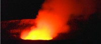
Hawaii Volcanoes National Park Kilauea Halema’uma’u crater live image

Hawaii Volcanoes National Park sign
Highlights:
+Dramatic volcanic landscapes
+Kilauea caldera and Halema’uma’u crater
+Diverse environments ranging from sea level to Mauna Loa (13,677 feet (4,169 m))
+Lush tropical rain forests
+Ka’u desert
+Endemic (only found in Hawaii) and native animals and plants
+Active eruptive site (Pu’u ’O’o)
+Volcano Goddess Pele
+Thurston Lava tube (Nahuku)
+1790 lava footprints and pyroclastic surge
+Ainahou ranch and the Shipman family
+Volcano House hotel
+Thomas A. Jaggar Museum and Hawaiian Volcano Observatory
+Holei Sea Arch
+Ancient Hawaiian Petroglyphs
+Kilauea Military Camp
Quick Facts:
Park established: August 1, 1916
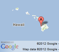
Location: Hawaii Island (Big Island), County of Hawaii, 19°23′0″N 155°12′0″W https://maps.google.com/maps?ll=19.383333,-155.2&spn=0.01,0.01&t=m&q=19.383333,-155.2
Area: 323,431 acres (505.36 sq mi; 1308.88 km2)
UNESCO World Heritage Site: since 1987
Visitors: >1 million/year
Directions:
United/Continental airlines offers daily flights from Los Angeles to Hilo, the nearest large city and airport to the Park. Air Canada, American, Delta, Hawaiian, Japan, Northwest, U.S. Airways/America West and United/Continental Airlines offer direct flights to the island.

Hawaii Volcanoes National Park map
Volcanic eruptions have the power to completely alter the landscape in just a few seconds. An erupting volcano is capable of destroying settlements, wiping out vegetation, and creating entirely new land surfaces from hardening lava flows, landslides and rock avalanches. Kilauea crater produces approximately 100 acres of new land every year.
Kilauea and Halema’uma’u crater
Where is the volcano? Kilauea lacks a distinct peak and lies on the southern flank of Mauna Loa. It was long believed that Kilauea was only a satelite of the much larger Mauna Loa but recent research revealed that Kilauea has its own magma chamber and its lava is chemically different than lava from Mauna Loa. The volcano is estimated to have first erupted 300,000 to 600,000 years ago, and has since stayed active, never experiencing any prolonged period of rest. It emerged from the sea about 50,000 to 100,000 years ago.
The Kilauea summit caldera is one of many pit craters in the area and was formed by the collapse of cooled lava following an eruption. The caldera is about 2-3 miles in diameter and 400 feet deep. Inside the caldera is Halema’uma’u crater. This smaller crater measures about 270 feet (83 m) deep and 2530 feet (900 m) across and contains a lava lake. The glow of the lava offers a spectacular sight at night. The crater emits a large plume of volcanic gas (mainly sulphur dioxide) wich is large enough that it can easily be seen from space.

Halemaumau crater aerial view

Halemaumau crater at night
Diverse environments ranging from sea level to Mauna Loa
Moisture from tradewinds creates extremes in rainfall within the Park supporting a wide diversity of lifezones and habitats. Seven ecological life zones include from low to high elevation: seacoast, lowland, mid-elevation woodland, rain forest, upland forest and woodland, sub-alpine, and alpine/aeolian.
The Hawaiian tropical rainforests belong to the tropical moist broadleaf forest ecoregion. Due to the long isolation, many endemic species can be found in the forests, including fungi, mosses, snails, and birds. The lush, moist forests are draped with vines, orchids, ferns, and mosses. Common plants are the Koa and ʻōhiʻa lehua trees as well as the Hapu’u Pulu fern.
back to top
The desert in the district of Ka’u features volcanic ash, small rocks, sand, and gravel. The desert has no vegetation due to acid rainfall. The acid rainfall occurs when volcanic sulphur dioxide combines with the moisture. The desert is frequently closed due to high volcanic activity of high concentrations of sulphur dioxide. Many ash footprints can be found here. Recent research suggests that people were in the area chipping off sharp chunks of glass to use as tools, and left the footprints while escaping during a lull in the eruption.

Kau desert
Endemic, native, and endangered animals and plants
Native animal species in the Hawaii are descendents of those that were able to come here with the 3 W’s before human arrival: Wind, Wings, Waves. They flew here (birds, bats, insects), were carried by birds (snails, some insects, spiders) or were blown here or washed ashore. Their descendents survived and reproduced to eventually colonize the inslands.
Plants and animals adapted to life without enemies, predators and plant-eating mammals.
Examples are the nettleless nettle, mintless mints, soundless crickets, wingless crickets, finches that became nectar feeders, flightless long legged owls that combed the beaches at night and the nene goose that once was a water bird but now has lost its webbing.
Endemic animals found inside the Park include six Hawaiian honeycreepers: ‘apapane, ‘amakihi, ‘i`iwi, and three listed as endangered; ‘akepa, ‘akiapola’au, and the Hawai’i creeper. There are also a native thrush (‘oma`o) and a native monarch (‘elepaio). Another three endemic birds are also endangered: the nene (Hawaiian goose), Ua’u (Hawaiian petrel), and ‘io (Hawaiian hawk).
23 species of endangered plants including the silversword and 15 species of endangered trees can be found inside the park.
Today’s threats to endemic life comes mainly though habitat loss, bird malaria, invasions of alien invasive plants, rats, cats, feral goats, mongoose, pigs and mouflon sheep.
Active eruptive site (Pu’u ’O’o)
Pu’u ’O’o is a cinder cone on the east rift zone inside the park that has been errupting continuously since January, 1983. Lava coming from this site has destroyed >150 buildings and 8.7 mi (14 km) of highways, many ancient Hawaiian sites, including the Wahaʻula heiau (temple). The coastal highway has been closed since 1987. It is covered with lava up to 100 feet (33 meters) high.

Pu'u O'o pit areal view

Pu'u O'o at night
In the Hawaiian religion, Madame Pele is the goddess of fire, lightning, wind, and volcanoes. She is a popular figure in many mythological stories of ancient Hawaii. Her home is believed to be Halemaʻumaʻu crater, but her domain encompasses all volcanic activity on the Big Island of Hawaiʻi. Every incident with a volcanic eruption in Hawaii it is said to be Pele’s way of expressing her longing to be with her true love, in many stories a young chief named Lohiau, but she’s a fickle and dangerous lover who eventually kills her husbands.
Pele has numerous siblings and relatives.

Volcano Goddess Pele
This 500 year old lava cave was formed by a river of lava that gradually built solid walls and a ceiling. When the lava flow stops and the last of it passes downhill, a tube is formed. These caves can be a few feet high and only short, or they can stretch for miles with high ceilings. The lava tube was discovered in 1913 by Lorrin Thurston, a local newspaper publisher.
Ancient Hawaiians used lava tubes as hideouts, for secret meetings, to collect water, and as burrial sites.
1790 lava footprints and pyroclastic surge
In 1790, a group of warriors (together with women and children) were caught in a violent eruption. Many were killed and others left footprints in the lava that can still be seen today but are not open to the public. Researchers measured the shoe sizes of the footprints and were able to determine the height of the people in the group and thus were able to determine how many women and children left footprints. The violent eruption is believed to be a pyroclastic surge. This fast moving flow of heated gas and rock can reach temperatures of 1,830 °F (1,000 °C) and speeds up to 450 mph (700 km/h). The most common scenario to produce such a deadly flow is the collapse of an eruption column where a large column of lava inside the crater spontaneously finds another way onto the surface. This alternate route is lower than the existing opening which causes the tower of lava above the new route to collapse and due to gravity, is violently forced out the new opening creating a pyroclastic surge.

1790 footprint
The Ainahou ranch and the Shipman family
The ranch was 6000 acres large and inside Volcanoes National Park. Herbert Shipman built a house on the remote ranch in 1941 as a refuge for the anticipated Japanese invasion of Hawaii. The ranch was used to raise beef for the military during World War II. Mr. Shipman also built pens to raise the nene goose and saved the species from extinction. After being threatened by a lava flow in 1969, the house was evacuated and the family reached an agreement for the National Park Service to purchase the land and house in 1971 to become part of Hawaii Volcanoes National Park.
Several small buildings were used as hotels throughout the years. The original building was built in 1877 and today houses the Volcano Art Center. The latest building was built in 1941 and had 42 rooms. The hotel had to be evacuated several times in 2008 due to volcanic sulphur dioxide. Since 2010, the hotel was closed for renovations. Since then, a new concessionaire was found and the hotel plans to reopen in 2012.
Thomas A. Jaggar Museum and Hawaiian Volcano Observatory
The volcano observatory and the museum are located at the Uwekahuna bluff on the rim of Kilauea caldera. The observatory monitors four active Hawaiian volcanoes: Kilauea, Mauna Loa, Hualalai, and Haleakala. Thomas Jaggar of the Massachusetts Institute of Technology was a volcanologist (geologist) who built the first full-time scientific observatory at Kilauea in 1912. From 1912 to 1919 Mr. Jaggar personally ran the facility. During this time, the first seismograph was installed. In 1919, the National Weather Service took over operations, and since 1924, the United States Geological Survey (USGS) operates it.
The museum shows exhibits on the work done at the observatory. The information ranges from general information on volcanoes and lava to the scientific equipment and clothing used by volcanologist.
The arch is a natural sea arch located at the end of chain of craters road. Like most natural arches, it formed as a narrow ridge, walled by cliffs, and became narrower from erosion.

Holei Sea Arch
Petroglyphs are found throughout the Hawaiian Islands but the Pu’u Loa area inside Volcanoes National Park contains about 23000 petroglyph images. They mainly show motifs containing holes, circles, other geometric designs, human representations, canoe sails, and feathered capes.
The petroglyphs are interpreted to have recorded travel around the island, express consideration for human longevity and well being, communicate events, and mark boundaries and trails.
Geologically, the lava in this area is dated to 1200-1450.

Petroglyphs
The Kilauea Military Camp is located inside Volcanoes National Park and serves as a Morale, Welfare, and Recreation vacation facility for active duty or reserve, retired military, department of defense employees, and their family members with lodging, dining, tours, entertainment, and recreation. The camp opened in 1916 and served as a Japanese internment camp and a prisoner-of-war camp during World War II.

Kilauea Military Camp
Reference: All images from wikipedia commons, USGS, and National Park Service